

An Arizona State University researcher is harnessing artificial intelligence to uncover how pedestrian environments in rural communities influence physical activity and cancer prevention
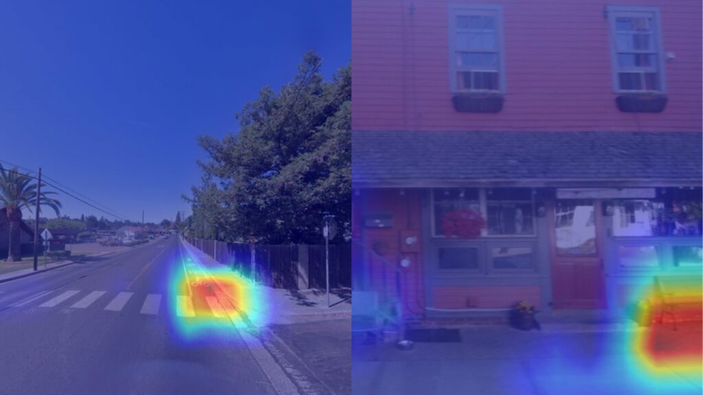
An example of the AI tool developed for the Pedestrian Environment and Physical Activity in Rural Landscapes project in action, successfully identifying pedestrian features. The project trains artificial intelligence using omnidirectional images like those used in Google Street View to recognize the features of a walkable environment, like sidewalks, curb ramps, crosswalks, benches and lighting. Courtesy photo
In the United States, nearly 97% of land is classified as rural — places often associated with wide open spaces and fresh air, not cancer risk.
Yet a 2024 study found that people living in rural areas experience higher cancer rates than their urban counterparts. Addressing those disparities requires new approaches to cancer research tailored to rural life — and that’s exactly what an Arizona State University faculty member aims to do.
School of Technology for Public Health Assistant Dean and College of Health Solutions Professor Marc Adams is leading the Pedestrian Environment and Physical Activity in Rural Landscapes, or PEARL, study, which uses artificial intelligence to better understand how rural pedestrian environments affect health.
The three-time grant-funded project trains artificial intelligence using omnidirectional images like those used in Google Street View to recognize the features of a walkable environment, like sidewalks, curb ramps, crosswalks, benches and lighting. The project’s most recent grant was awarded by the National Institutes of Health and the National Cancer Institute in March 2025.
“The goal is to build a scalable tool that can map these features in rural and urban places across the country and use that information to guide prevention efforts, including cancer prevention,” said Adams.
The artificial intelligence developed for this project eases what would otherwise be hours of slow, expensive work conducted by trained researchers onsite who would walk each block with a tablet, manually recording their findings — especially challenging in Arizona’s harsh summers.
“What would have taken months or years for teams of humans can now be done in a matter of days,” said Adams.
After data collection, nine mapped features were linked to the activity levels of community residents, paying close attention to differences in walking and physical activity support. For Adams, the aim is to use this data to mobilize community advocates to vie for investments such as improved lighting or additional sidewalks.
“If we get those investments into communities that are underserved, we have the potential to reduce some of the gaps in physical activity and, over time, in cancer and other health outcomes,” said Adams.
Below, Adams describes how his research is making a big impact one step at a time.
Question: How does this work intersect across the College of Health Solutions and the School of Technology for Public Health?
Answer: From the (College of Health Solutions) side, we bring expertise in population health, physical activity, cancer prevention, and methods for measuring neighborhoods and health behaviors. We are asking solvable health questions. For example, how do environments shape physical activity, and how might that translate into differences in cancer risk for people living in rural communities?
From the School of Technology for Public Health side, we fuse the public health, technology and engineering approaches that make this work possible. We are building and refining tools that can scan millions of street-level images in hours, identify key pedestrian features, and turn that into usable, actionable data for planners and policymakers. This project is a good example of what we envision for the School of Technology for Public Health: public health questions paired with technology and engineering solutions that can be deployed to help real communities.
Q: What is the importance of this research?
A: Physical activity is one of the most powerful health behaviors we have for preventing many cancers and other chronic diseases, yet we still know relatively little about how rural environments help or hinder people who want to be active.
Most of our current measures of community “walkability” were built for cities. They focus on big-picture features, like how dense the street network is or how many destinations are nearby. Those macro-level features are important, but they are expensive to change and do not always fit rural settings. In many rural areas, the more immediate question is whether there is a safe shoulder to walk on, a crosswalk or crossing signal near the school, or enough lighting to feel safe walking in the evening.
Our research fills that gap by focusing on micro-scale features, such as sidewalks, curb ramps, crosswalks and lighting, that are more affordable, politically acceptable and realistic to improve in rural communities. By using AI, we can measure these features at scale in places that have rarely been studied before and then link them to patterns in physical activity. That helps us identify where investments in basic pedestrian infrastructure could make the biggest difference for community health and pedestrian safety.
Q: How can a project like this address health disparities between people who live in rural versus urban communities?
A: We know that people who live in rural communities often have higher rates of many chronic conditions, including certain cancers, and they also have fewer resources that support healthy behaviors. Rural residents are, on average, less physically active for recreation.
We also know that rural places differ. There are larger rural towns that look almost urban, very small towns with a main street, and very isolated communities where there is no downtown at all. Within those places, racially and ethnically diverse and lower-income communities often have the fewest pedestrian safety features, which can add another layer of inequity.
Projects like PEARL help address these disparities by first making the invisible visible. Many rural communities do not have basic maps of where sidewalks, crosswalks or lighting exist. By using AI to create these maps and link them to physical activity, we can identify which rural neighborhoods are missing supports for safe walking and who is most affected.
By: Eden Miller | February 9, 2026 | Original Post